| ROADS |
East & West MoleseyA Dictionary of Local HistoryRowland G. M. Baker, 1972 |
| ROADS |
|
|
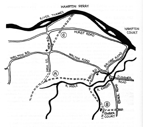
Road Communications of East and West Molesey A Conjectural course of road by river Mole B Course of original road to Esher and Thames Ditton C Course of original road to Hampton Ferry |
It is probable that soon after the founding of permanent settlements in the Mole Valley a trackway near the river bank at least from Cobham to the Thames. As time went by the track developed into a road for wheeled traffic. Bell Road, a portion of Walton Road, and Bridge Road were probably parts of this. (See A on sketch plan). The road by the river must have been very wet, and in winter extremely difficult to traverse. In time, therefore, parts of it were allowed to fall into disuse, people preferring to use the drier road via Apps Court.
Roads also ran to other adjacent settlements, Walton, Esher, and Thames Ditton. Molesey's peculiar peninsular position, surrounded on three sides by rivers, greatly influenced their siting and their use. The road to Thames Ditton, for example, was absolutely impassable for much of the winter and so became the "Summer Road" by which it is still known today. Even during drier periods visitors to Molesey were accustomed to clamber through a multitude of "water splashes". The road to Esher left East Molesey by crossing the Mole alongside Tanners Bridge, across the common, over the slipstream of Ember Mill, and crossing the river Ember passed in front of the mill and Ember Court. Here it divided, one road leading directly to Esher along what is now More Lane, and the other to Thames Ditton along the present Embercourt Road. (See B on sketch plan). This road passed across at least three fords. It was still sporadically used sporadically used for traffic until the middle of the last century.
The transportation from the old road to the present Esher Road/Ember Lane route springs from two causes. Firstly in 1725 the mansion of Ember Court was acquired by Arthur Onslow, Speaker of the House of Commons, who wished to move the road further away from the house and build a park in front of it. He diverted the road along the line of what is now Ember Lane and Orchard Lane. In 1773 his son received royal licence to close up the "old highway for carts, carriages, and foot passengers which passed through his property and run from Thames Ditton and Esher to East and West Molesey". This then created a really tortuous route from the Esher area to Hampton Court. The second stage occured when Hampton Court bridge built in 1753. As the bridge was privately owned and the proprietor collected tolls, it was obviously in his interest to encourage as many people as possible to cross the bridge. He therefore obtained Parliamentary permission to construct a road from the corner of Onslow's diversion to rejoin the old road opposite where the police station now is. This necessitated the building of bridges across both the Ember and the Mole. The road, which is of course the present Esher Road, by-passed the previous circuitous and splashy road fell into disuse and was finally closed when a barn was built at Orchard Farm in 1887 effectively blocking the way. Since when it can only be used by pedestrians.
From Hampton Ferry two roads ran across the Hurst. One to East Molesey, part of which is now Hurst Lane. The other proceeded straight across the Hurst to the village of West Molesey. This road also has been twice diverted. Firstly in the eighteenth century, when Hurst House was built, the part south of Hurst Road was moved further away from the house, the diverted part being called the "New Road", as it still is. Secondly the part north of Hurst Road was diverted in 1890 to permit the enclosure of Hurst Park, the road now called "Ferry Road". (See C on sketch plan).
The road to Walton, via Apps Court, lay in the one direction by which it was possible to leave or enter Molesey without being hampered by rivers. This road too was diverted, in 1639, to take it further away from the mansion of Apps Court and to create a park around it. The diversion can still be traced.
The Hurst Road was possibly built in Tudor times as a direct link connecting the two great royal palaces of Hampton Court and Oatlands.
All books copyright © R G M Baker, all rights reserved.
Images © 2006 M J Baker and S A Baker, all rights reserved.
Web page design © 2006 M J Baker and S A Baker, all rights reserved.